Many would ponder why on earth you would want to visit Death Valley in August. At the time of writing, Death Valley holds the record for the world’s highest recorded temperature, so the prospect of visiting in the height of summer may strike some as odd, and others as downright mad. The reason we chose to visit in August was curiosity, plain and simple. We have spent the last 3 and a half years living in Southern California where temperatures regularly exceed 100°F in the summer. But 120°F / 130°F… what does that feel like? With Death Valley National Park being less than 5 hours drive away, we decided to find out!
Where to stay
For our accommodation, we decided to base ourselves away from the heat of the park itself and stayed in a lovely little AirB&B in Pahrump. In hindsight we found the drive in and out of the park added a bit too much to the day and I would seek something a bit closer next time around. But on the plus side, we did get to enjoy a fantastic meal at Symphony’s Restaurant at the Pahrump Valley Winery, which we would highly recommend.
If you do choose to stay in the park and your budget is not constrained, The Oasis at Death Valley would definitely be the place to stay. Your only other option would be The Stovepipe Wells Village Hotel. Otherwise, for accommodation outside of the valley itself, check out the nearby areas of Beatty, Panamint Springs and Death Valley Junction where you will find a few options.
Considerations of visiting Death Valley in August
It’s going to be hot (well, duh!). But when I say hot, I mean birds sometimes drop from the sky hot. At 282 feet below sea level, Death Valley boasts the lowest point in North America and the mountains on either side of the valley trap the heat in. Combined with an average rainfall of less than 2 inches a year, these conditions earn the park its claim of being the hottest, driest and lowest National Park in the National Park System.
In August, the average daily high is 116°F. You will need to ensure you drink plenty of water, use an abundance of sunscreen and bear in mind that hiking is not recommended after 10am. Also have enough food and drink provisions with you in the car in case of car troubles- cell service in most of the park is non-existent, so it’s best to plan for the worst but hope for the best.
Please do check the Death Valley National Park Safety Page before your visit to ensure you know what to expect. For us, much of our trip was stopping at key locations, having a short look around before jumping back in the car. I’m sure we’ll be back to explore more and undertake some hikes in cooler months, but not in August!
The best route in to Death Valley from the East
We had a day and a half to explore the park and I’ll detail how we mapped out our time below, along with what you could add on to fill the full 2 days at a leisurely pace. On the first day we opted to take Route 178 from Shoshone into the park, despite it not being the fastest route in, and we exited heading East on the 190. Entering the park this way allowed us long, sweeping views of the valley as we entered the park, and also allowed us to schedule our stops in a logical order. On the second day we entered and exited the park on the 190 heading East to West.
My personal preference for entering the park from the East is definitely Route 178; it has a more majestic feel. Exiting the park heading West on the 190 is quite spectacular and very hilly. Be sure your car is running well and topped up with water- it’s a challenge for cars going up these hills at any time, but factor in the heat and it could just be too much.
This is in fact where they test a number of pre-production vehicles for problems- we saw many of them on our second day. We also stopped to help a family whose car had broken down going up the hill on the way out of the Park. Cell service is non-existent, so all we could do was get the store at Panamint Springs to call for help and provide them with the coordinates. It’s not somewhere you want to be getting stuck!


Day 1
Ashford Mill Ruins
Heading in on Route 178, we stopped for photos with the National Park sign and at a few other scenic points along the road. Our first proper stop was at the Ashford Mill Ruins. This is not an essential stop by any means, but if you are passing it doesn’t take long to stop in, see the ruins and read about the early commercialisation of the park. I wouldn’t make a special journey here, but if it’s worth pulling in if you are entering or exiting the park this direction. Bonus points for the fact that it has a restroom; super useful if you are travelling with kids with small bladders like ours!

Badwater Basin
The second stop is the main attraction, Badwater Basin. This is arguably the most famous spot in Death Valley, with the valley floor’s salt flats stretching out almost 200 square miles and boasting the accolade of being the point of lowest elevation in North America. Most people when they think of Death Valley will conjure images of the honeycomb-like crystalised polygons that cover the desert floor as far as the eye can see. That’s Badwater Basin.
To get to the crystalised part, you will need to walk out from the parking lot on the well trodden trail approximately quarter of a mile. For the best views and photographs, carry on for at least half a mile. I recommend arriving early if you can to avoid the excessive heat. When we were there it was midday and 119º so we never made it out to see the famous polygons. I was sad about it but it was the sensible decision, especially as it isn’t difficult for us to return to Death Valley at a cooler time of year.


Devil’s Golf Course
Next on our itinerary was Devil’s Golf Course, just a quick drive from Badwater. From the main road, you drive down a short dirt track where you can stop to view the strange sharp, and spiky salted lumps on the floor surface that have been formed over hundreds of years. This is a short stop, but an interesting one, allowing you to marvel at the fascinating shapes that have been naturally sculpted by the elements.


Artist’s Drive
Next up, just north of Devil’s Golf Course is Artist’s Drive and this is one you should be sure not to miss. It’s a 9 mile long one-way road that winds up and down with great views of both the mountains and the salt flats. The star of the show here though is the array of colors on display in the hills of the road’s main stop, Artist’s Palette (so called because of the obvious comparison of the colors of the hills and that of a painter’s palette). The magical effect is down to the oxidation of metals in the rock and it’s a fascinating thing to see.
Again, if you can bear the heat (we couldn’t), you can take the steps down and across the wash and walk out around the hills for the best experience of them. We opted instead to climb up the mound adjacent to the parking area for a better look, as 1pm in August is no time to be hiking in Death Valley!
Once you are done exploring Artist’s Palette, you continue on the last four miles of Artist’s Drive back to the main road.


Furnace Creek Visitor’s Center
This is a decent Visitor’s Center and we spent a good amount of time here looking at the exhibits and learning about the park (as well as stamping the kids’ National Park Passports, an essential for any National Park we visit!). The famous attraction here is the giant thermometer that stands outside, an essential photo opportunity for any summer visitor to the park. I have to confess that I was a little disappointed that it was a mere 119ºF when we were there; I had been hoping for higher considering were visiting Death Valley in August!


Zabriskie Point
Zabriskie Point is a beautiful viewpoint that can be accessed via a short circular walk up to the platform from the parking lot. It is well worth making the stop here to admire the elegant flow of the mud hills and the rugged, color-contrasted rocks that jut up out of them on the northern side. My kids had fun trying to count all the hills, which could have gone on all day had it not been for the heat! Again, at risk of sounding like a broken record, there are hikes you can do from here to get up close and personal with the stunning mud hills, but it’s probably not advisable in August!


Dante’s View
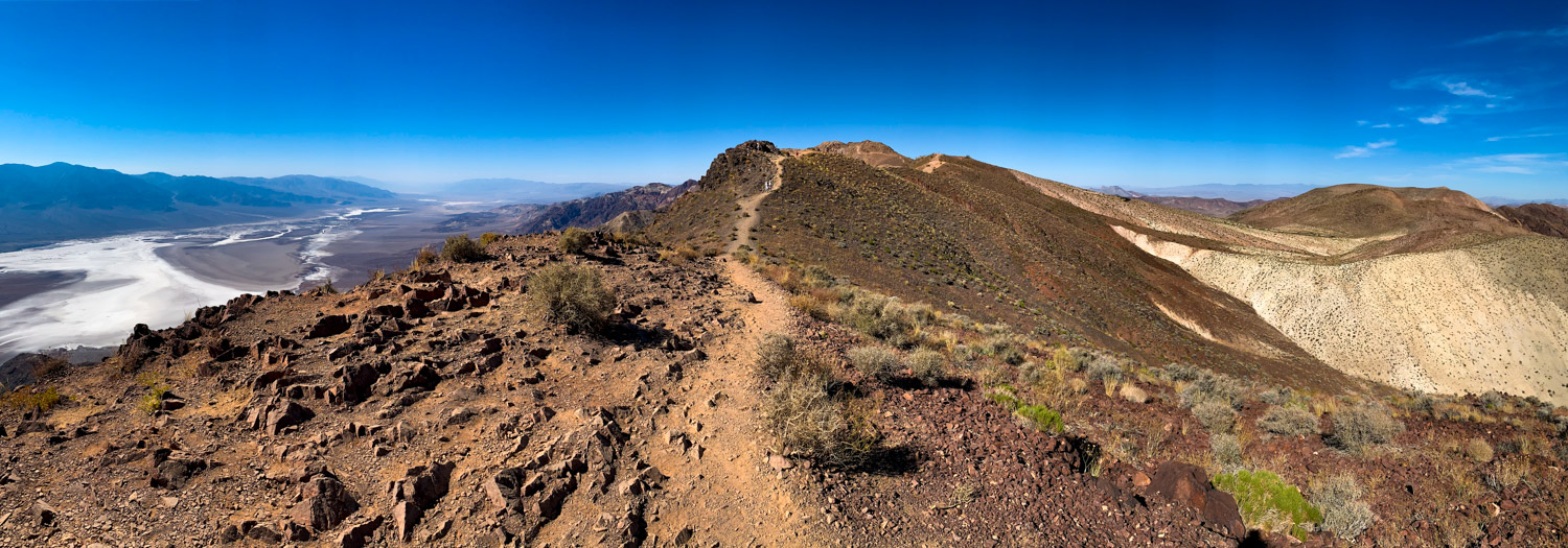
Our final stop of the day was at the breathtaking Dante’s View. At just under 5,500 ft elevation, the temperature was finally comfortable enough to be able to tackle the short walk out to the viewpoint (you can go either direction from the parking lot and neither route is longer than a mile).
We opted to take the southern route and it was absolutely stunning. Looking down on the vast salt flats stretching out for almost 200 square miles below with the backdrop of the mountains on the other side is really quite spectacular. It’s also fun to look out for the tiny cars traversing the roads of the valley below or the even tinier hikers out on the salt flats, which helps give you some perspective on the scale of the largest National Park in the contiguous United States. This stop may be a bit further out of the way, but it absolutely should be on your itinerary for your visit.


Day 2
Day 2 was a short day for us as we were heading back home, but we decided to do so by driving through the park from East to West. We had one more stop we wanted to make before heading out, but I’ll also include some additional ideas for other stops you may want to add if you are planning a second full day in Death Valley.
Mesquite Flat Sand Dunes
Recalling images to your mind of how you imagined desert dunes to look as a kid, the Mesquite Flat Sand Dunes are the real deal. Take a wander out along the dunes and climb up, slide down and traverse along the hot, hot sand (don’t make the mistake that I did- be sure to wear closed toe shoes!).
If you are so inclined and have the gear, the Mesquite Flat Dunes are the only dunes in the park where you are permitted to sandboard (yes, it’s just like it sounds- it’s basically snowboarding… but on sand). Another one that’s probably not all that practical in the height of summer, but it’s definitely something I’d like to try in the cooler months!
The dunes were quite busy when we went, making it hard to get decent photos. Like most places, the best photos can be had by venturing further from the parking lot.


Other potential stops in Death Valley
Ubehebe Crater
I was so sad that we never got to see the crater! But with it being over an hour’s drive north of Furnace Creek and home being in the opposite direction, we opted to save this one for our next trip to the park during cooler months.
Ubehebe Crater is a ginormous crater, half a mile across and 600 feet deep. It’s an impressive geological site created by a volcanic explosion, thought to be possibly as recently as 300 years ago. The impressive scale of the crater and the array of colors on display in the rock make this a worthwhile stop. The crater can be viewed from the parking area, or you can hike around the edge or into the crater (but if you choose to do this, do so early before it gets too hot).
Scotty’s Castle
During our visit in August 2019, and also at the time of writing, Scotty’s Castle is closed due to flood damage and is expected to remain closed until at least 2022. But if you are reading this in 2022 or later, then do check the National Park page to see if it has re-opened yet. It’s just over 20 minutes drive from Ubehebe Crater in the northern section of the park, so it makes sense to do both if you are heading that way.